The Regional Cabled Array
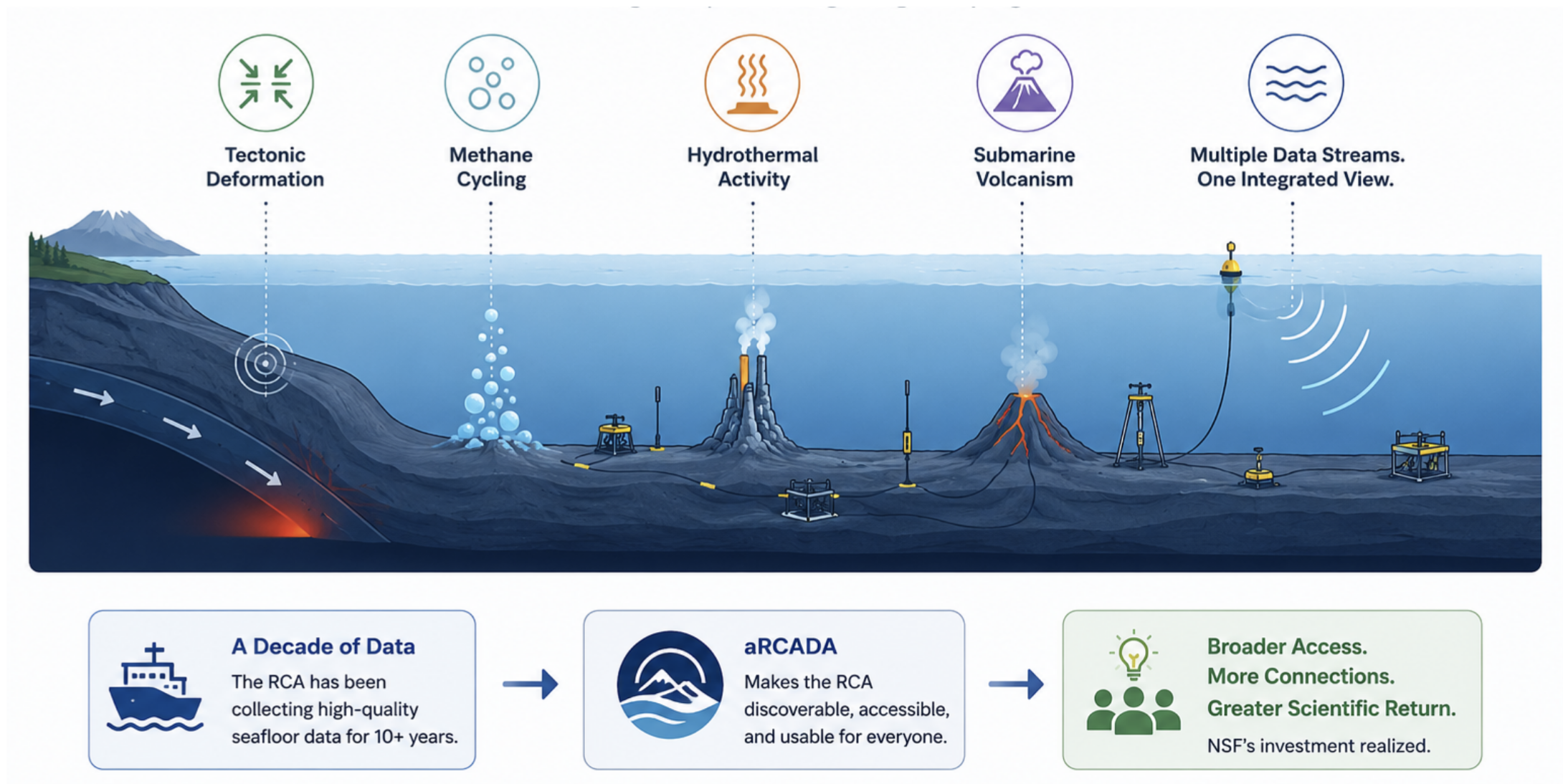
Off the coast of Oregon, a network of instruments sits on the seafloor, quietly recording one of the most dynamic environments on Earth. Ocean bottom seismometers capture the rumble of earthquakes and volcanic eruptions. Pressure sensors track the gradual rise of the seafloor as a volcanic caldera inflates beneath it. Hydrophones listen for the acoustic signatures of methane bubbles rising from cold seeps. Together, these instruments — as part of the NSF-funded Ocean Observatories Initiative (OOI) Regional Cabled Array (RCA) — have been generating a continuous, decade-long record of the Juan de Fuca tectonic plate, home to the Cascadia Subduction Zone, methane seeps, hydrothermal vents, and Axial Seamount, an active submarine volcano.
The data is rich and abundant, bridging marine geology and geophysics as well as biological, chemical, and physical oceanography through over 140 seafloor instruments — but reliably accessing all this diverse data is a bottleneck to interdisciplinary research output.
The Problem: A Decade of Interdisciplinary Data, Limited by Fragmented Systems
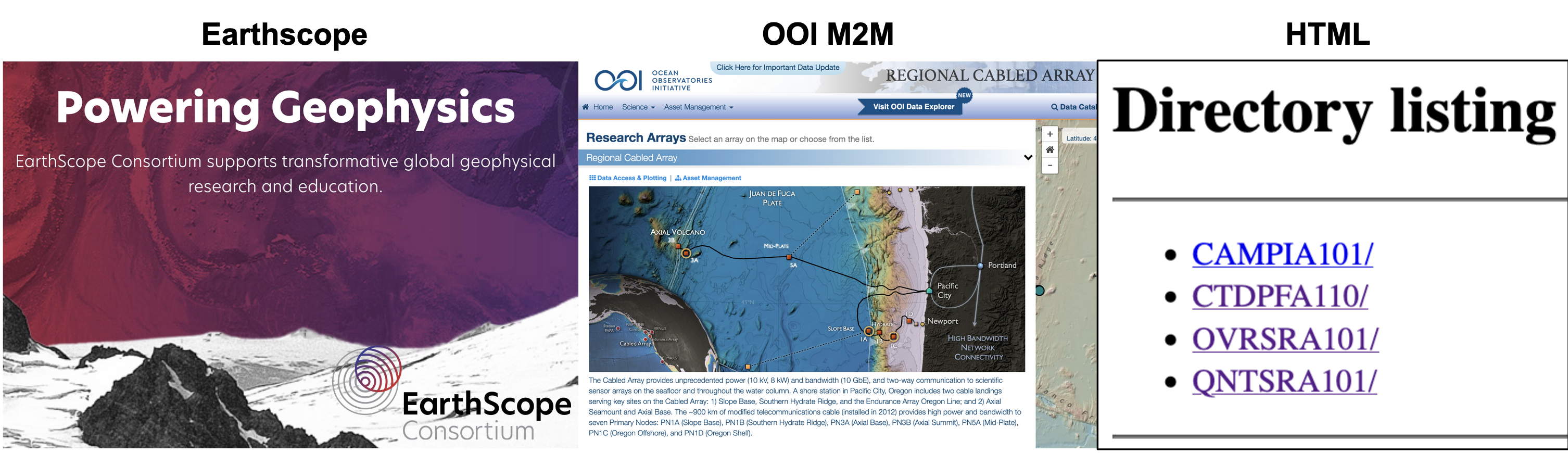
The RCA hosts dozens of instruments across two major networks, OOI and EarthScope, plus a collection of PI-operated instruments managed by individual researchers. Some instruments offer clean, programmatic access through a REST API. Others store raw sensor readings on standalone HTML pages with no metadata, no consistent structure, and no documentation. A geochemist who wants to compare methane flux anomalies with seismic activity doesn't just need domain expertise — they also need to become fluent in two completely different data retrieval systems, build a web scraper for an HTML site, and manually stitch together data streams that were never designed to talk to each other.
The result? Researchers invest considerable time accessing data rather than pushing the bounds of science — or worse, they only use the instrument data with which they are already familiar. Cross-disciplinary science — the kind that could reveal how a submarine volcanic eruption contributes to trace iron cycling in the ocean, or how slow-slip earthquake cycles are related to methane seep activity — becomes challenging, not because the data doesn't exist, but because accessing it is too inefficient.
Our Approach: aRCADA
aRCADA (a Regional Cabled Array Data Assistant) is an AI-powered framework that lets researchers access RCA data through plain-language requests. Instead of learning API endpoints or parsing HTML directory listings manually, a researcher can simply ask:
"Show me bottom pressure and seismic data near Axial Seamount for the two weeks following the 2015 eruption."
aRCADA interprets the request, identifies the relevant instruments across OOI, EarthScope, and PI-operated sources, and surfaces them in a unified interface.
The system is built in three layers. A curated instrument catalog captures metadata for every relevant instrument: its location, data type, source system, and scientific context, as well as papers published using those instruments. The catalog is built with instrument specifications and descriptions from the RCA website, alongside specific metadata pulled from data storage locations. All of these are pre-built and stored locally to keep response times fast. Additionally, the catalog includes abstracts for all papers published on RCA data, as well as full-text content for open-access papers — also built locally from a Zotero folder to minimize per-message latency. These are indexed into low-dimensional embedding space by chunk, and each catalog update is re-indexed against the previous embedding to minimize token cost.
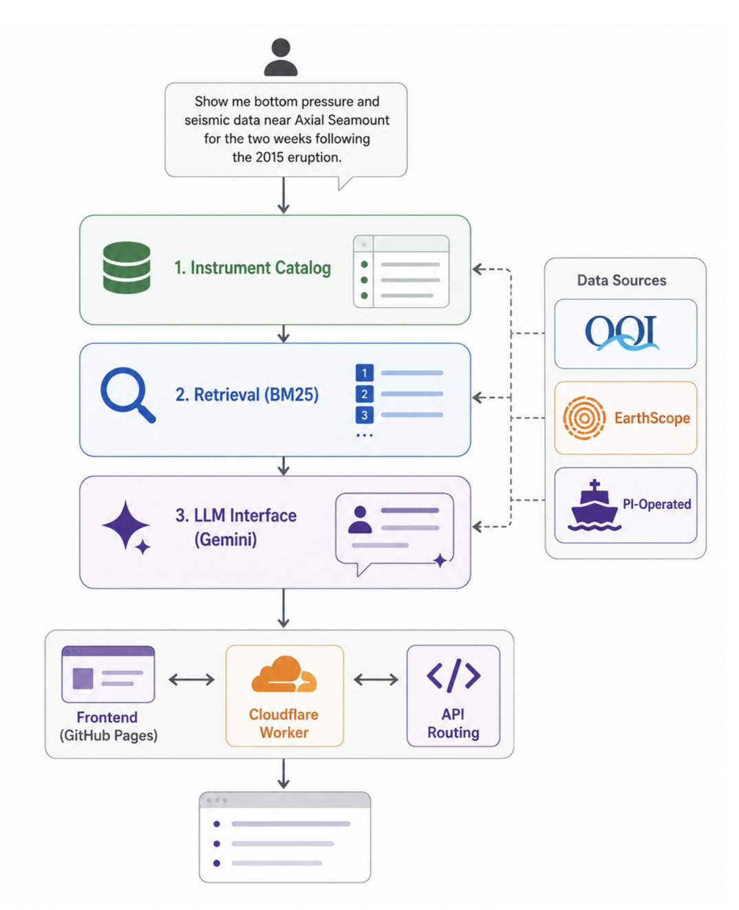
A retrieval system uses BM25 keyword search to match plain-language queries against the catalog, surfacing the most relevant instruments and publications for any given request. Separate BM25 searches are performed for instruments and for papers, where the four best-matched instruments and papers are returned. Each instrument and paper is assigned one vote, such that the number of embedded chunks does not unequally bias results toward instruments with more known information. Finally, a large language model (powered by Gemini's Flash Lite 2.0, among several other lightweight Gemini models) is given the relevant chunks for top-matching instruments and papers as well as the user's request, to provide a conversational interface explaining what instruments are available, what they measure, what research has been published, and what a data request would look like — with an interactive data pull script interface.
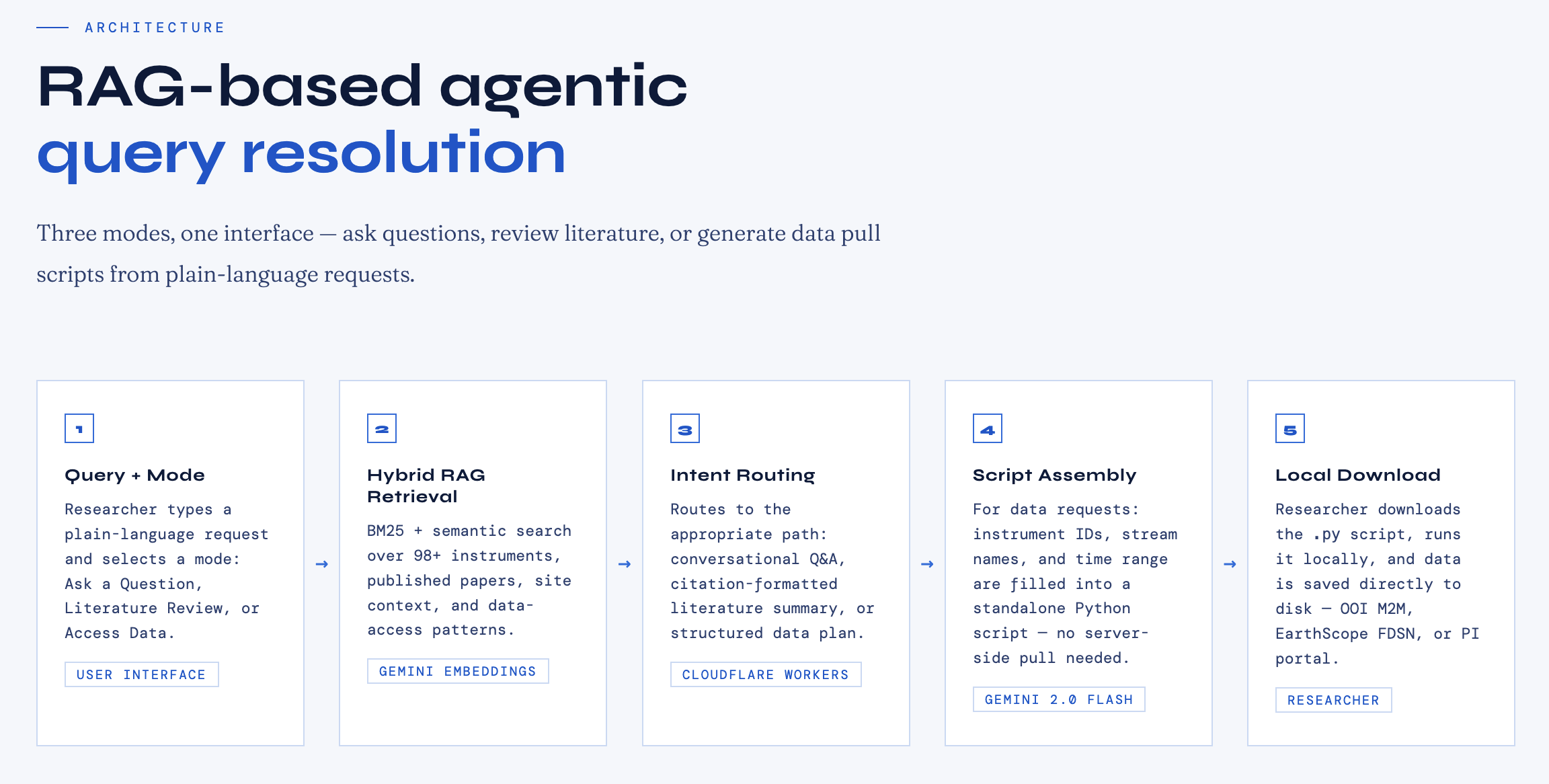
The frontend is deployed as a static site on GitHub Pages, with a Cloudflare Worker handling API routing. This keeps the architecture lightweight and cost-effective — no servers to manage and no infrastructure to maintain.
What Works Today
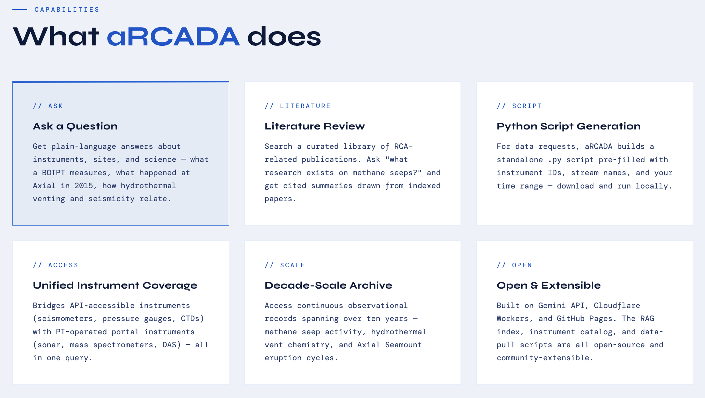
The instrument discovery and literature review components are working end-to-end. A researcher can type a query like "What instruments can detect methane bubble plumes at Southern Hydrate Ridge?" on the "Ask a Question" tab, and within seconds, they see a ranked list of matched instruments with their locations, data types, and source systems, alongside a conversational explanation from the AI and a structured data plan showing exactly which instruments would be pulled and why.
The "Literature Review" tab surfaces relevant published research from the RCA community, giving researchers immediate scientific context alongside instrument metadata. Papers are linked with DOIs, authors, and publication venues.
The "Access Data" tab pulls relevant instrument metadata for multiple instruments based on the conversation and propagates a Python-based data download script that can be copied or directly downloaded. The agent fills in templates for different data request types and combines them together for seamless data access in one script.
What's Next
The full data retrieval pipeline — Python scripts that pull data from the OOI API, EarthScope FDSN, and PI instrument web servers and package it as analysis-ready Zarr archives — is implemented but not yet integrated into the live demo. This is the hardest part of the system: the OOI API requires asynchronous requests for large time ranges, EarthScope data must be fetched day-by-day to manage memory, and the PI instrument pages require custom scrapers for each instrument's idiosyncratic format. Plus, pulling data with an API call driven by the agent is an intractable problem on a token-limited system. Greater computing resources and a local agent — such as one based on Llama — could address this.
Future directions include a more in-depth literature base that retrieves and synthesizes relevant papers with deeper knowledge, a VSCode integration for running data pull scripts locally, and a lifecycle carbon assessment framework for data pull jobs. In the future, this agent could serve as the foundation for the forthcoming NSF-funded Cascadia Offshore Subduction Zone Observatory (COSZO), which is expanding the number of instruments deployed on the seafloor for advancing fundamental science as well as natural hazards monitoring.
Why It Matters
The Juan de Fuca plate system is one of the most scientifically compelling regions on the planet. The processes unfolding there — tectonic deformation, methane cycling, hydrothermal activity, and submarine volcanism — are inherently interdisciplinary. They cannot be understood through any single data stream or field of expertise.
The RCA exists precisely to make integrative science possible. aRCADA exists to make the RCA accessible. By lowering the barrier to cross-disciplinary data exploration, we hope to help ensure that the NSF's decade-long investment in seafloor observation translates into the broadest possible scientific return.
The RCA has spent a decade collecting data — aRCADA helps scientists realize its full potential.